The Republic of Mauritius is located approximately 1134 kilometers (704 miles) East of Madagascar. Its territory consists of a main island (Mauritius), Rodrigues, Agalega, and Saint Brandon. The main island is divided into nine districts; Black River, Flacq, Grand Port, Moka, Pamplemousses, Port Louis, Plaine Wilhems, Rivičre du Rempart, and Savanne. Port Louis is the capital of the country and is the only city. The towns on the main island are Beau Bassin and Rose Hill, Curepipe, Quatre Bornes, and Vacoas and Phoenix. There are 129 villages on the main island.
A postcode is a code used by the post office to sort mail. A postcode consists of a group of alphanumeric chratcters. Postcodes (code postal) were introduced in Mauritius in 2014.
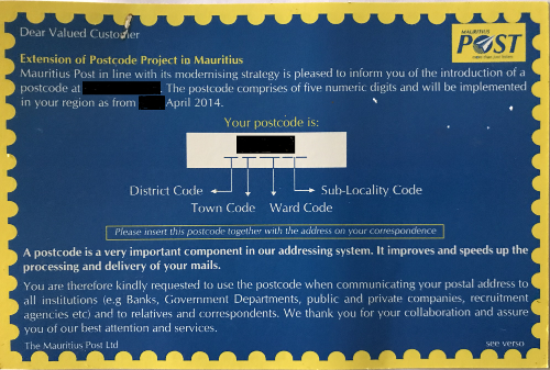
According to the Universal Postal Union, Mauritius uses a five digits postcode; the first digit is a District Code, the next two digits are a Village Council Area Code, and the last two digits are for the Sub-Locality Code. The Postcode Information Card (above image) states there are five digits; the first digit is the District Code, the second digit identifies the town and the third digit and fourth digit identify the ward in the town.
A postcode for Agalega begins with the letter "A" and is followed four digits. A postcode for Rodrigues begins with the letter "R" and is followed by either three or four digits.
1. https://www.lexpress.mu/article/252247/code-postal-reste-convaincre-population, "Code postal: reste ą convaincre la population", September 2014
2. http://www.upu.int/fileadmin/documentsFiles/activities/addressingUnit/musEn.pdf, "Universal Postal Union", September 2014